
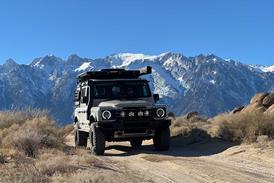

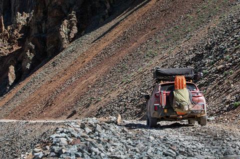
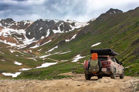
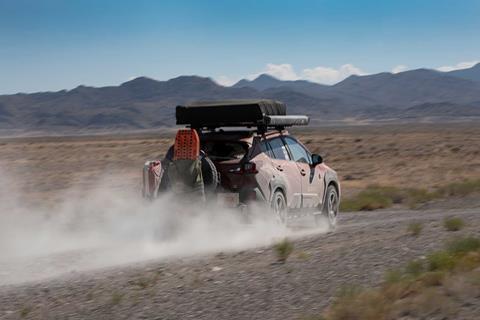
After conquering the eastern United States, the real challenge began. Days 16-29 of the TransAmerica Trail brought Colorado’s San Juan Mountains, Utah’s scorching desolation, Idaho’s flatlands, and Oregon’s wildfire-ravaged forests. With 39 route deviations, extreme elevation gains exceeding 12,000 feet, and temperatures topping 111 degrees, this couple pushed their modified 2025 Subaru Crosstrek Wilderness to its absolute limits—proving that determination and proper preparation can overcome nearly any obstacle on the path to the Pacific.
This article is the final installment in a three part series. Read Part 2 of our TransAmerica Trail (TAT) series, where we get a firsthand look at what it’s like to drive the demanding middle section of the trail in a mildly modified 2025 Subaru Crosstrek Wilderness.
As we left the eastern half of the nation, we prepared for our biggest challenge yet: the San Juan Mountains and the western United States. My husband, Andy Lilienthal, and I tackled the entire east-to-west-coast section of the TransAmerica Trail (TAT).
We touched the Atlantic Ocean at Nags Head, North Carolina, to start our grand cross-continent venture and made it to western Oklahoma. The last segment of our slow-going journey documents Days 16-29 through New Mexico, Colorado, Idaho, and Oregon.
We battled extreme elevation gains, wildfires, exceptionally desolate conditions, and more storms just to face sinkholes and treacherous trails. Would our trans-continental trek be successful? Yes, but it came with cautionary tales as we made our way westward, averaging 25 mph during the entire trek.
Build, Upgrades & Equipment
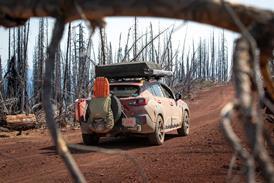
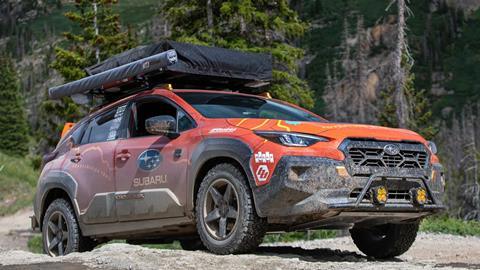
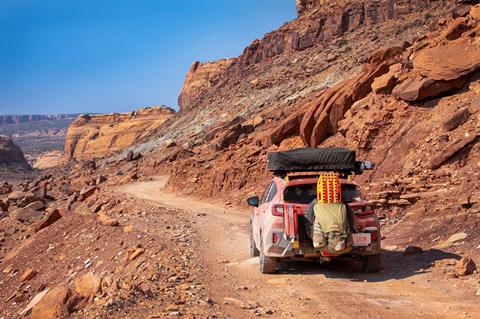
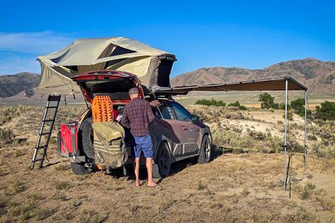
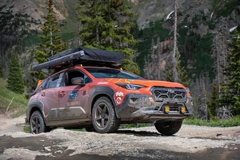
We worked with Subaru of America to devise a purpose-built 2025 Subaru Crosstrek Wilderness for the TransAmerica Trail. We wanted to create an overland adventurer we could live out of for a month or more. Andy and I are experienced off-roaders, and we’ve learned what upgrades and gear are critical for self-supported travel.
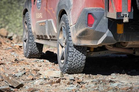
BFGoodrich KO2 all-terrain tires (on Reika Seeker wheels), increased traction. Primitive Racing skid plates protected the underbody. Baja Designs XLR-Pro LED aux lights mounted on a Rally Innovations light bar mount helped us see in low-light conditions.
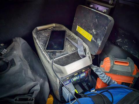
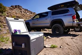
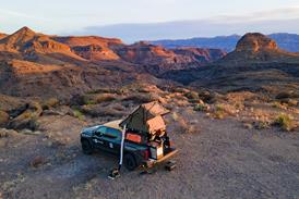
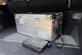
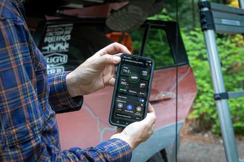
We slept in a Thule Approach rooftop tent and employed an ARB awning for shelter. We installed an EcoFlow 800W Alternator Charger and Delta 3 Plus power station to keep our ARB fridge, devices, and the Subaru itself charged.
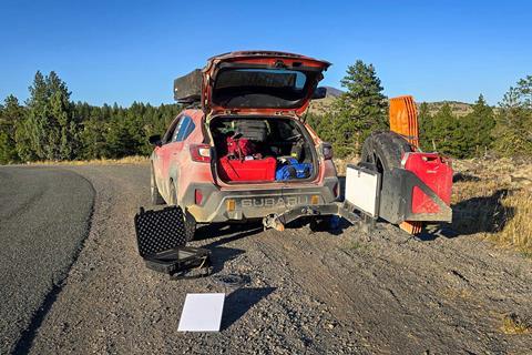
A Rig’d Supply UltraSwing Short-Fit swing-out tire carrier was fitted with a SideHack extension (for extra fuel) and an UltraTable (for a work surface). This gave us additional cargo-carrying ability.
We affixed four Maxtrax Xtreme recovery boards and a Trasharoo to the full-size spare. (Tip: Maxtrax’s new Lite boards work well for Subarus and small SUVs, too.
We ran a Factor 55 HitchLink 2.0 rear recovery point and brought a basic vehicle recovery kit from them, too. We also used an ARB single portable air compressor to air up and packed an ARB Speedy Seal tire patch kit in case we got a flat. (Thankfully, we didn’t.)
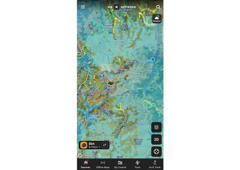
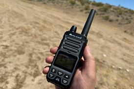
We used Garmin’s Tread Overland and GPSMAP 67i devices for GPS/inReach capabilities, and the onX off-road app to monitor trail conditions and more.
Quad Lock device mounts kept smartphones secure and Pelican cases and a Front Runner Outfitters Typhoon duffel kept contents organized.
Days 16-17—Great Plains Bunk House, Boise City, OK, to Daley Gulch Primitive Camp Near Sargents, CO
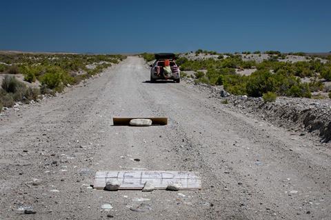
As we left Oklahoma’s mud and severe humidity, we were greeted with drier, dustier conditions. We drove past thousands of prairie sunflowers and wild morning glories as the terrain changed from dark red to a light peachy white.
We clipped northeastern New Mexico and headed into south-central Colorado. The mighty San Juan Mountains were nearby! But first, we stayed at a hotel in Walsenburg.
Day 16 was July 4; there were no BLM areas to access and local campgrounds were full. We had hit at least 90° for 15 sticky days straight. We showered and slept.
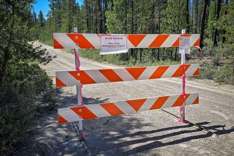
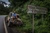
Day 17 included our 28th unplanned route deviation due to a closure on Poncha Creek, just off CR 200 near Marshall Pass.
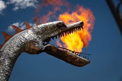
We also made a pit stop to see Bishop Castle in the San Isabel National Forest. It’s a one-man wonder: a massive building constructed with tons of local stone and featuring a fire-breathing dragon head.
Enter at your own risk; make sure you have an up-to-date tetanus vaccination if you do so. We saw three rams and stayed at our first primitive campsite: Daley Gulch in Saguache County. We connected to our Starlink Mini and prepared for high-elevation mountain passes.
Mileage to date: 4,128 (1,539.7 off-road). Total time driven: 190 hours, 30 minutes. Route deviations off TransAmerica Trail: 28.
Anticipation Grows
So far, we’d driven nearly 4,200 TAT miles, with over 1,500 miles being dirt, gravel, and mud. Now came rocks, and lots of them.
Temps swung nearly 60 degrees in one day. We awoke to ice crystals on the Subaru. We started Day 18 with thick anticipation of Colorado’s San Juan Mountains; we were in for a fight.
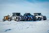
TAT is mainly for adventure motos, but 4x4s do it, too. Not often does a near-stock AWD vehicle attempt what we’re doing. We don’t have low range, lockers, or other 4x4-equipped accoutrements.
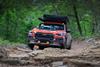
However, our 2025 Crosstrek Wilderness was fully capable until this point. We crossed countless water crossings, did dirt, didn’t get mired in mud, and tackled the toughest section of Arkansas’ Warloop Road unscathed.
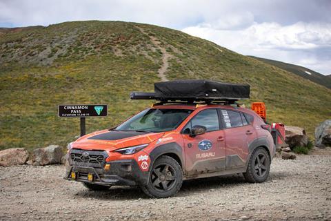
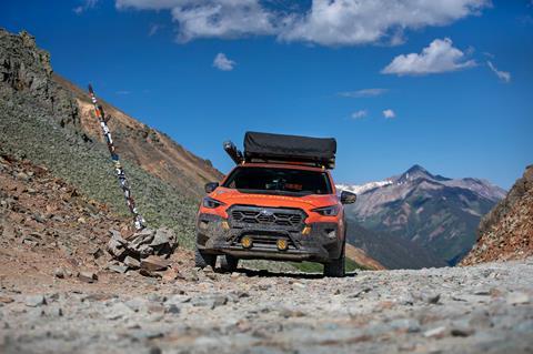
We knew our trusty but weighted-down Subie would feel the effects of extreme elevation gain. TAT crosses several San Juan passes, to the tune of 12,000-13,000+ feet above sea level. They included Cinnamon Pass, California Pass, Ophir Pass, and more.
Day 18—Daley Gulch Primitive Campsite Near Sargents, CO, to Historic House, Lake City, CO
First up: Cinnamon Pass at 12,640 feet, then California Pass shortly thereafter. We refueled in Lake City and methodically made our way up the first section of Cinnamon Pass.
The trail increased in difficulty. It showcased tight, ledge-filled turns and slow, rocky sections. We reached a trail intersection at 11,300 feet and were approached by the owner of a beautifully built Willys who needed fuel. His fuel cell was running on fumes, so we gave him five gallons from our jerry can.
Our mantra: Help people, especially in remote or challenging areas. We pressed past the “4WD recommended” sign, intending to respect our limitations if the trail got too tough.
The Crosstrek was surefooted albeit slow, but we successfully reached the Cinnamon Pass summit! We were soon approached by a perplexed 4x4 owner wanting to know how we got our Subaru to the summit.
“We drove it up here,” Andy exclaimed, noticing he was stunned to see it among several 4x4s and side-by-sides. We descended the rocky trail to Animas Forks and started up California Pass, and then we hit a major roadblock: snow.
There was a bypass around a steep 90-degree incline to start the pass’s upper switchback portion. However, it was mid-June, and that bypass was covered in a few feet of snow. We were forced to try the incline.
Our Garmin Tread Overland read over 12,500 feet. Our Subaru Crosstrek Wilderness fought for every bit of oxygen, but the route was too steep. The Subaru finally met its match; its CVT couldn’t put the power to the ground.
So we turned back, repeated Cinnamon Pass backwards, and stayed overnight in the driveway of a kind Subaru enthusiast’s home in Lake City. The kindness of strangers never ceases to amaze us.
Mileage to date: 4,310 (1,673.9 off-road). Total time driven: 202 hours, 50 minutes. Route deviations off TransAmerica Trail: 30.
Days 19-20—Historic House, Lake City, CO, to Sand Flats Recreation Area, Moab, UT
We were disappointed with California Pass but elated that the Crosstrek Wilderness did everything else we asked of it and more.
The Primitive Racing skid plates were a must-have for the San Juans and our BFGoodrich KO2 all-terrains kept us on the straight and narrow.
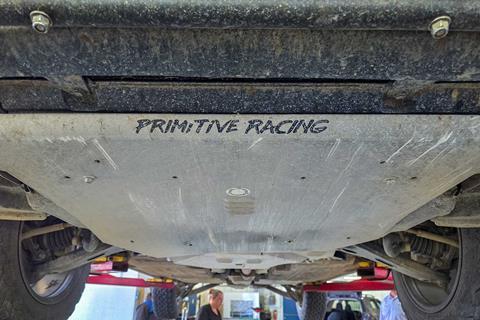
We deviated to Montrose, Colorado, and Flower Subaru gave our underbody a once-over to make sure we were in tip-top shape. The skid plates had sustained several scrapes and a few dents, but the Subie checked out great.
Soon, we found another primitive camp spot outside of Silverton, Colorado, and called it a night. Ophir Pass tomorrow!
Ophir Pass (11,789 feet) is a loose and rocky shale trail that challenges many vehicles. Once again, we were the only all-wheel-drive car up there and we successfully finished with the help of our underbody protection and all-terrain tires.
We drove through the picturesque San Miguel Mountains and pushed past La Sal, Utah, to Moab for a special dinner and evening: It was Andy’s birthday the next day!
We camped at our favorite secluded spot in Moab’s Sand Flats Recreational Area, but the heat was relentless.
Mileage to date: 4,679 (1,834.1 off-road). Total time driven: 224 hours. Route deviations off TransAmerica Trail: 30.
Days 21-27—Sand Flats Recreation Area, Moab, UT, to Cascade Lodge, Bend, OR
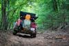
We doubled back to La Sal, rejoined TAT, and drove Geyser Pass Road up and over 10,000 feet above sea level. Thick aspen groves and barren hillsides gave way to Moab’s famous red slick rock.
The heat intensified, so we got a hotel away from 111-degree temps. (We endured several days over 100 degrees.) Thankfully, our Subaru had great air conditioning which helped keep us cool.
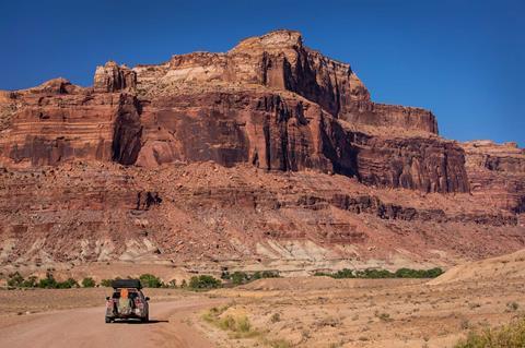
Andy and I completed the Gemini Bridges trail, leaving Moab on Day 22. We then encountered Utah’s extreme desolation, passing Dubinky Well, Horse Bench Reservoir, Labyrinth Canyon, the San Rafeal Reef Wilderness Study Area, and Death Canyon Road. Terrain changes occurred frequently as triple-digit temperatures continued to plague us.
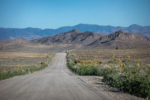
Utah’s scenic backways were rutted and rough. We helped a stranded off-grid local who was without her vehicle or power for two weeks and then pressed through lower Idaho, where speeds increased and the scenery flattened out. Before we knew it, we were in eastern Oregon.
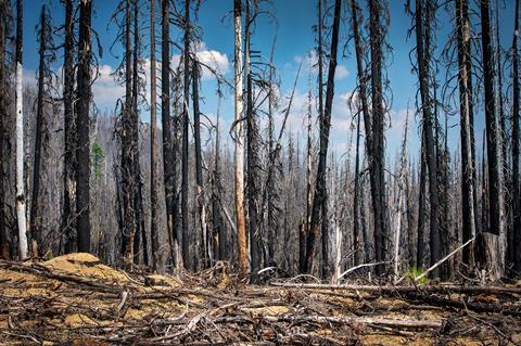
Thick smoke from nearby wildfires enveloped us soon after when we were deep in the Malheur National Forest. We deployed our Starlink Mini once the trees thinned to check nearby fires, and we decided we needed to get out of a potentially perilous situation.
Our 35th route deviation bypassed a remote section of TAT off NF-16 to get to Highway 395 north of Seneca more quickly. Our Baja Designs auxiliary lights helped cut through the smoke and we drove through the night to get back to civilization. We stayed at a local motel in John Day where support was nearby if we needed it.
Day 27 gave us further issues. We tackled freshly burnt areas, road closures, and more route deviations. We could barely breathe when we stopped to air down at Highway 20 and Moffitt Road.
Andy checked the ambient air quality to find that it was 29.5 times worse than the healthy recommendation. We couldn’t camp, so we deviated into Bend for another motel and fresh air.
Mileage to date: 6,490.4 (2,892.4 off-road). Total time driven: 300 hours, 15 minutes. Route deviations off of the TransAmerica Trail: 36.
Day 28—Cascade Lodge, Bend, OR, to Hemlock Lake Campground in Umpqua National Forest, OR
Hampered by burning eyes and wildfire worries, we dealt with more wildfire-ravaged deviations as we crossed China Hat, Windigo Pass Road, and other damaged areas. Running low on fuel, we bypassed part of TAT in favor of Highway 138.
We stopped at the Dry Creek Store, gassed up, and found our way back to TAT after traversing NF-4720, a burned cliffside track. It was another 100-degree day.
Mileage to date: 6,691.7 (3,008.4 off-road). Total time driven: 308 hours, 30 minutes. Route deviations off TransAmerica Trail: 38.
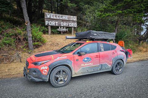
Day 29—Hemlock Lake Campground in Umpqua National Forest, OR, to Sea Crest Motel, Port Orford, OR (the finish)
This day tested our patience, off-road ability, and stamina. Ravens started rousing before 5:00am. Would we finish on Day 29, our 21st wedding anniversary? We left Umpqua National Forest east of I-5 and traversed deep into the Rogue River Siskiyou National Forest. This lush area posed plenty of challenges.
NF-3230 had partial washouts. NF-3353 was impassable due to a sinkhole and other flood damage. We backtracked seemingly forever, deflated but determined. We wanted to celebrate at the The Crazy Norwegian’s Fish & Chips in Port Orford, a staple place for TAT-goers!

Our 39th deviation was long, but we got back on track and completed our 29-day journey in time for dinner. We had traveled through 15 states and 20 national forests successfully and without mechanical issues.
We touched the Pacific Ocean to solidify our month-long achievement and promptly passed out at the only available motel left in town.
Mileage to date: 6,898 (3,082.6 off-road). Total time driven: 317 hours, 5 minutes. Route deviations off TransAmerica Trail: 39. Total mileage (adjusted for a slightly larger tire size): 7,163 overall, with 3,184 being gravel, dirt, mud, and rocks.
More Images from the TransAmerica Trail’s Western Frontier in a Subaru Gallery


Access More Great Stories!
This article originally appeared in OVR Issue 18. For more informative articles like this, consider subscribing to OVR Magazine in print or digital versions here. You can also find the print edition of OVR at your local newsstand by using our Magazine Finder.


No comments yet